|
Satellites are very important to our daily lives and we don't even realise it. "A satellite is a moon, planet or machine that orbits a planet or star" (NASA). A satellite is launched into space by a rocket and once its speed is balanced by Earth's gravitational force, it starts orbiting. Different satellites orbit at different speeds, height and path depending on its purpose. The two main types of satellite orbits are geostationary and polar.
A geostationary satellite orbits the Earth at the same speed as the Earth spinning on its axis meaning that from Earth, the satellite would in the same position. It orbits from west to east. A polar satellites orbits the Earth from North to South around the Earth. A communication satellite is basically a satellite that allows the transmission of television, radio and telephone signals over long distances. Satellites allows us to watch television, make in-flight phone calls, use GPS, monitor the climate, listen to the radio and many more. We will be only looking at a few in detail. |
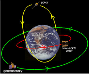
The two main types of satellite orbits are geostationary and polar.
|
Satellite Television
|
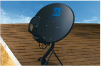
Look in your backyard or on the roof of your house there may be a satellite dish or an antenna. These receive signals from communication satellites in space (if you are using a satellite television). To simply put it, a communication satellite basically receives TV signals from a broadcasting station in Earth and then redirects it to other locations on Earth.
But why go through this trouble? Can't you just send the signals directly to houses? |
|
Broadcast televisions uses this method but some problems arose from this. The broadcast station transmits television signals to the surrounding areas so the household antennas can receive the signal. These signals though, travel in a straight line and because Earth is round, the signals will eventually be out of the line of sight of antennas - that is, it is out of the range from the antenna (the signal will travel off the face of the Earth). So range is an issue; if your antenna is far from the broadcasting antenna, picking up the signal will be difficult, also accounting for big obstacles like buildings or hills. The only to get a clear signal is to have an antenna that is close to the broadcasting antenna and away big obstacles.
Satellites in space have a greater line of sight because it is higher up and is therefore a more preferable way of transmitting television signals. |
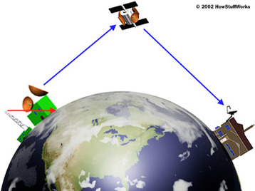
The satellites in the space have a greater line of sight because it is higher up.
|
GPS
GPS replaces the trouble of maps. We rely on them for navigation. They help us find our way when we are lost. GPSs are such useful devices but... how do they work?
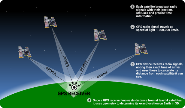
GPS stands for Global Positioning System. They can calculate your speed, distance to your destination, direction of movement and how long it would take for you to arrive. GPSs uses about 32 solar-powered satellites that send information about its position and current time on radio waves (microwaves). These satellites are at approximately 20 000 km above the Earth's surface, each orbiting on different paths around the Earth two times a day. The satellites carries atomic clocks that allow them to tell the time. They are in positions that allows GPS receivers on Earth to detect and receive information from at least 4 satellites anytime. Once the GPS receivers receives the information from the satellite, they calculate your approximate location on Earth to the nearest metre using a process called trilateration.
GPS stands for Global Positioning System. They can calculate your speed, distance to your destination, direction of movement and how long it would take for you to arrive. GPSs uses about 32 solar-powered satellites that send information about its position and current time on radio waves (microwaves). These satellites are at approximately 20 000 km above the Earth's surface, each orbiting on different paths around the Earth two times a day. The satellites carries atomic clocks that allow them to tell the time. They are in positions that allows GPS receivers on Earth to detect and receive information from at least 4 satellites anytime. Once the GPS receivers receives the information from the satellite, they calculate your approximate location on Earth to the nearest metre using a process called trilateration.
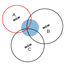
Trilateration
|
Using the data - position and current time - receiver works out how far the satellite is from itself. This is calculated by how long it has taken for the data to be received (when the receiver receives the data, it takes note of the time). Once the distance has been found, trilateration is used. In simple terms, the receiver draws circles, with the distance being the radius around each satellite. Obviously, the location of the GPS is on the circumferences of the circles. The point where three of the circles intersect is when your location is. Your receiver does this, but uses spheres instead of circles.
Time is crucial in accuracy of determining the GPS's location because a few milliseconds off can pinpoint a different location. All of these steps are done within a few seconds! |
|

|
Moon is a natural satellite - it orbits the Earth. Earth is a natural satellite too because it orbits the Sun.
|
